In December 2025, I did a six-day solo backpack on the South Kaibab and Clear Creek Trails in the Grand Canyon.
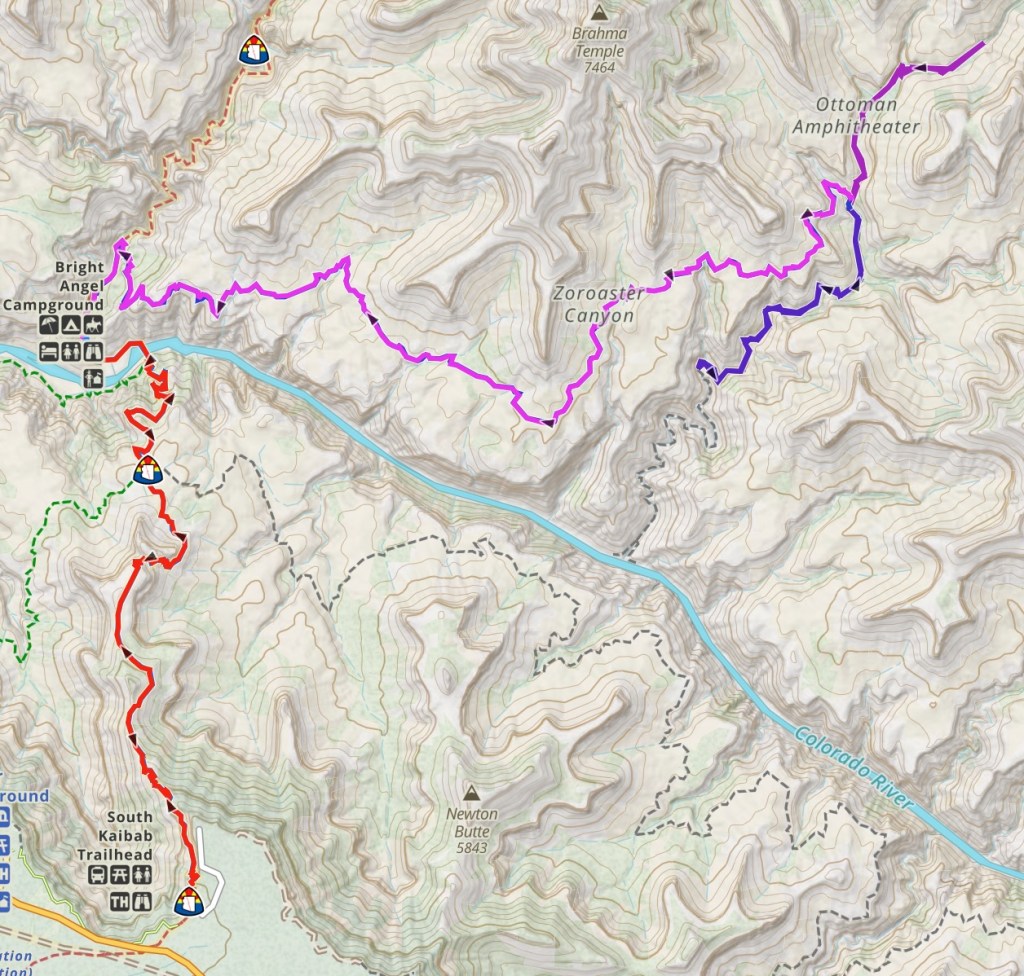
12/2/2025 – South Kaibab Trail to Bright Angel Campground: My first day I hiked down the South Kaibab trail to Bright Angel Campground. It was fun to do this trail again, as it was the first trail I backpacked in the canyon back in May 2023. The advantage of doing it in December is that you don’t have to start nearly so early to avoid the heat and there are also a lot fewer people. In fact, because I walked to the trailhead from a parking spot on Desert View Road instead of waiting to catch the first shuttle bus, I had the trail all to myself until Cedar Ridge, which was quite delightful. It was a balmy 35 degrees when I started just before 8 AM and about 50 degrees when I arrived at Bright Angel Campground around 12:15 — perfect hiking weather in my opinion! I scored one of the nice creek-side campsites and spent the afternoon setting up camp and filling all my water containers at Phantom Ranch. The ranch was closed to overnight visitors due to a pipeline break, but the canteen was open and they had one water spigot turned on for the backpackers. With the ranch closed and the campground not being full, the whole place felt quite sedate, not at all like when I was there in 2023.
12/3/2025 – Clear Creek Trail to Clear Creek Camp: My main motivation for this backpacking trip was to hike the Clear Creek Trail, which is another mid-canyon trail like the Tonto Trail. But the Clear Creek Trail runs on the north side of the river; it is also the only trail that traverses the Tonto Platform on the north side. The trail starts from the North Kaibab Trail about a quarter mile north of Phantom Ranch and it climbs steeply to an overlook of Phantom Ranch, before beginning a long traverse that eventually ends at some lovely campsites next to Clear Creek. The trail is south facing and in the sun all day, so it is not a good one to do during the hotter months, but it seemed perfect for a December backpack. The most amazing part of the Clear Creek Trail is just after the overlook, where you walk along the base of the Tapeats Sandstone for almost a mile and are face to face with the Great Unconformity, a gap in the geologic record that spans more than 1 billion years. Prior to my departure, the forecast for 12/3 indicated a 20% chance of showers before 11 AM, but when I got up that morning, the cloud cover made it seem like there was a much higher probability of rain. And right after I left the overlook, it did begin to rain lightly, so I put on my rain jacket and kept hiking. About an hour later, when I was up on the Tonto Platform and getting close to Sumner Wash, the rain began to fall in earnest and I stopped under a convenient overhang to put on full rain gear. It stopped raining just before I got to where the trail turns north and starts heading up the Clear Creek drainage below Demaray Point, but I kept my rain gear on as the clouds still looked threatening. I was quite relieved when I got to the final descent into Clear Creek and could see and hear the creek, as I was feeling the effort of covering 9.3 miles, with lots of up and down (2,100 feet of ascent; 1,000 feet of descent) and a full pack.
12/4/2025 & 12/5/2025 – Exploring Clear Creek: I set up my backcountry permit for three nights in the Clear Creek Use Area, so that I could use the Clear Creek Camp as a base camp to explore the drainage, which is one of the larger ones in the canyon. On my first day, I enjoyed a very leisurely morning to help with my recovery from the effort to get to camp, so I didn’t start my upstream exploration until 10:30 AM. My plan was to follow the main fork of Clear Creek upstream as far as I could get by my turnaround time of 12:30 PM. The route finding wasn’t too bad, as there was a mostly-easy-to-follow social trail with a few nicely placed cairns, and the canyon is pretty wide open as you head upstream. The only challenge was finding a good place to cross a stream coming in from a side canyon without getting my feet wet. In the end, I made it about two miles up the creek before turning around. If you follow the creek upstream about five miles, you get to a place where you can view Cheyava Falls, which is the Grand Canyon’s tallest at over 800 feet. But it only flows in the spring after a good snow year, so I was content with my short exploration and will just have to go back another time if there’s a chance to see Cheyava.
On my second day, I got an earlier start, as I was headed downstream and I hoped to cover a bit more distance. I started at 8:30 AMand set a turnaround time of noon, but it was quickly clear that my progress was going to be quite slow as the route finding was a lot more challenging. At times there was an obvious social trail, but mostly it was an ever changing puzzle to figure out the best route. The drainage quickly turns into a narrow gorge as you go downstream and that means lots of creek crossings as you get cliffed out on one side or the other. And sometimes the best route is to leave the creek bed and go up and over instead. After running nature’s obstacle course for three hours, I had covered just over two miles and decided that it made sense to stop at a sharp u-bend in the creek where there was a nice rock with a little waterfall. My return trip did go a lot more quickly and, miraculously, I managed to keep my feet dry despite the countless creek crossings. It would be fun to hike down Clear Creek all the way to the Colorado River, but I’ll need to get better at route finding and have a lot more daylight for that to be possible.
The campsites at Clear Creek are really nice, but the problem with December is that they are only in the sun from about 9 AM to 2 PM. So when I arrived back at camp each afternoon, it was already in the shade. And with temperatures in the mid-40s, it was really hard to avoid getting chilled, even though I changed into dry clothes and put all my layers on. My solution was to make hot cocoa and sit in my chair under my Ultamid, with my feet tucked into my sleeping quilt.
12/6/2025 – Clear Creek Trail to Bright Angel Campground: After three great nights at Clear Creek Camp, it was time to reverse my course and head back to Bright Angel Campground. The weather for my return trip was the complete opposite of my hike there — sunny and not a cloud in the sky. I actually prefer a few clouds in the sky, as it makes for better photos. The hike back was much more pleasant, with a much lighter pack and more downhill than uphill, although the downhill below Phantom Overlook was a bit steep. And the views were great, with Zoroaster Temple on my right shoulder for most of the way. When I arrived at the campground around 2 PM, I was shocked that I was still able to score one of the prime creek-side campsites.
12/7/2025 – South Kaibab Trail from Bright Angel Campground to South Rim: For my hike out to the South Rim, I wanted to start around sunrise, so I was up at 5:15AM to pack up camp. It was amazing how much light there was from the moon — I barely needed my headlamp to pack up. I had the trail all to myself all the way to Tipoff (except for a downhill mule train) and I was the only person at Tipoff when I got there — it’s rare to have so much solitude on the South Kaibab Trail! I made good time on my ascent, getting to the rim around 12:30 PM and thankfully I only had to play chicken with the tourists for about the last mile. This was the first time I’ve backpacked all the way from the river to the rim in a day and I was happy with how I did, although I will admit that I was pretty wiped out for the next two days!